Beyond the Field Visit: Integrating Remote Sensing and Field Data for Enhanced Natural Capital Monitoring
August 26, 2026|Will Johnson
Co-Author, Bickham Crooks, Forest Manager for Carbon Verifications and Nursery at ACRE Investment Management
Key Takeaways
- Verification fieldwork and technology are complementary. LiDAR, multispectral imagery, sensors, and geospatial analysis can expand the evidence available beyond that from traditional field sampling and independent verification.
- Remote sensing can expand coverage and accelerate issuance. Wall-to-wall data can reveal patterns that individual sample plots may miss while shortening the time needed to collect and analyze information after the growing season.
- Natural-capital monitoring extends beyond carbon. Integrated technology can help assess biodiversity, water, soil, resource health, and climate response alongside carbon stocks.
- Continuous data creates a more complete record. Monitoring conditions between verification events can identify changes sooner and support carbon estimates, risk assessments, and land-management decisions.
For decades, environmental verification has relied on periodic field sampling. Trained professionals visit a project, measure selected plots, review documentation, and use those observations to estimate performance across a much larger landscape.
That work remains essential. But nature is dynamic. Forests grow, weather patterns shift, habitats evolve, and soil and water conditions change between scheduled verification events. Periodic measurements alone cannot always capture the full story of how a landscape is performing.
At ACRE, we are expanding the evidence base by combining traditional fieldwork and independent verification with remote sensing, LiDAR, multispectral imagery, in-field sensors, predictive analytics, and AI-enabled analysis.
The goal is not to replace established verification practices. It is to strengthen them with more complete, consistent, and timely information.
From Sample Plots to the Digital Acre
Field sampling provides detailed measurements from specific locations. Remote sensing adds another layer: the ability to observe conditions across an entire project area.
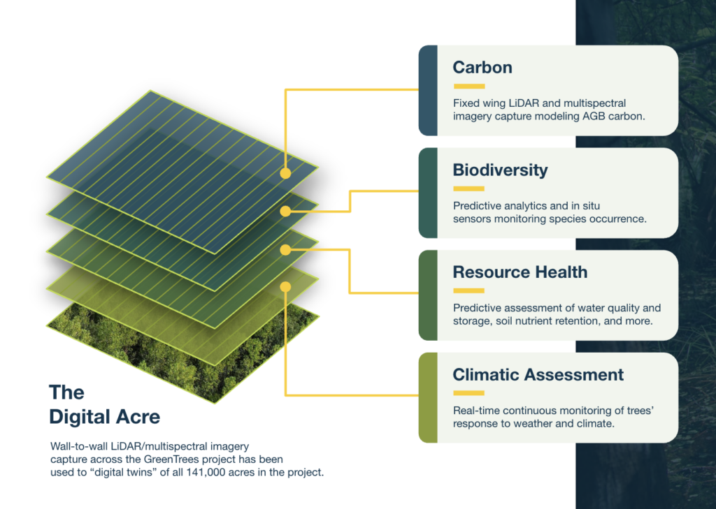
Across the GreenTrees reforestation project, ACRE has used wall-to-wall LiDAR and multispectral imagery to create digital representations of approximately 141,000 acres. These “digital acres” provide a more comprehensive view of the landscape, helping identify patterns, monitor changes, and understand variations that individual sample plots may not reveal.
When remotely sensed information is connected with field measurements, each source of data strengthens the other. Field observations help validate what technology detects, while remote sensing provides greater visibility across the full project area. It can also accelerate data collection and analysis after the growing season, helping shorten the timeline from final measurement to verification and credit issuance.
The result is not simply more data. It is a stronger and more timely understanding of what is happening on the ground and how those conditions change over time.
Measuring More Than Carbon
Natural-capital projects create interconnected outcomes. A growing forest does more than store atmospheric carbon. It can provide habitat, support water quality, retain soil nutrients, reduce erosion, and respond differently to changing weather conditions.
That is why ACRE’s Nature Intelligence Platform looks beyond a single metric. Our technology stack brings together multiple methods to evaluate four dimensions of landscape performance.
Taken together, these layers help us move from measuring a single environmental output to understanding a more complete natural-capital system.
Carbon Removal: Beyond Verifications
Credible carbon accounting increasingly requires more than periodic field sampling alone. GreenTrees and its partners combine ground-based measurements with LiDAR, multispectral imagery, and geospatial analysis to quantify and validate carbon stocks across the project—creating a broader evidence base for understanding forest growth and change over time.
- Wall-to-wall coverage with fixed-wing LiDAR and multispectral data capture across all 141,000+ acres enrolled in the project
- Optical intelligence to measure and identify individual trees within digital plots
- Geospatial analysis for additional assurance
Supporting Biodiversity: More Than Carbon
As companies look beyond carbon to understand their broader impacts on nature, biodiversity monitoring is becoming an increasingly important part of project evaluation. GreenTrees and Map of Life are implementing a framework that combines geospatial analysis, in-situ sensors, and other techniques to assess species richness and abundance across project lands—and to better understand how reforestation influences ecological conditions over time.
- Predictive analysis of remotely sensed habitat structure to infer associated wildlife species
- Bioacoustic sensors to continuously and autonomously record vocalizing species
- Camera traps to detect larger and/or non-vocal wildlife
[RELATED: The Synergy of Agroforestry and Bottomland Hardwood Afforestation]
Resource Health: Farm Benefits
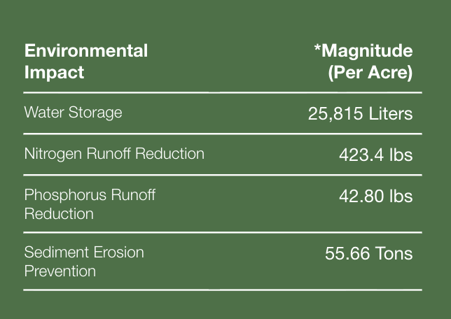
Beyond sequestering carbon, reforestation can improve water storage, nutrient retention, soil stability, and other ecosystem functions that support surrounding agricultural lands. ACRE and its partners use predictive models to quantify these benefits, including water-quality improvements, reduced sediment runoff, and greater landscape resilience.
- Bioremediation of surface runoff, avoiding eutrophication of waterways
- Water storage in soils and biomass, supporting ecosystem resilience
- Runoff reduction via stabilization of soils from root mass
Climatic Assessment: Risk Monitoring
ACRE and its partners are deploying a network of dendrometers to continuously monitor how forests respond to changing climate conditions. These real-time insights into tree growth and stand performance can strengthen carbon estimates, improve risk monitoring, and inform more effective management decisions.
- Carbon estimation inferred from tree growth as subtle as 1/4th the width of a human hair
- Oxygen saturation and its impacts on tree health
- Cooling as a proxy for ambient moisture levels in and around trees
[RELATED: Advanced Carbon Restored Ecosystem]
Stronger Technology, Stronger Evidence
Technology does not eliminate the need for sound methodologies, field measurements, independent audits, or transparent reporting. It strengthens the evidence available to support them.
LiDAR improves visibility into forest structure. Multispectral imagery can reveal vegetation conditions across large areas. In-field sensors capture information between scheduled site visits. Predictive analytics can identify patterns, anomalies, and potential risks that warrant further examination.
When these methods are integrated, they can help project teams:
- Detect changes sooner
- Compare performance across large and diverse landscapes
- Improve measurement consistency over time
- Identify areas requiring additional field review
- Create clearer data trails for buyers, investors, and verification bodies
- Shorten the time between the end of the growing season and credit issuance
This matters because confidence in natural capital markets depends on more than just a final number. Stakeholders increasingly want to understand where the data originated, how it was evaluated, what was directly observed, and what was modeled.
A broader evidence base can help answer those questions while also improving project management. The same information used to support carbon accounting can reveal changes in forest health, ecological conditions, and climate-related risk.
Verification Should Be a Living Process
A forest does not grow only when a verification visit occurs. Habitat conditions, soil moisture, weather patterns, and vegetation health change continuously. The way we monitor natural capital should reflect that reality.
By pairing field expertise with multiple forms of technological observation, ACRE is working toward a model in which verification is supported by a growing body of evidence—not simply a snapshot captured at one moment in time.
That is the promise of the Digital Acre: a more detailed, connected, and transparent understanding of how land performs across carbon, biodiversity, water, soil, and climate.
Better technology alone will not create integrity. Rigorous methodologies, experienced field teams, transparent reporting, and independent verification remain fundamental. But technology can make environmental outcomes more visible, risks easier to identify, and project performance more accountable.
For natural capital to become a durable, investable asset class, its outcomes must withstand scrutiny. Building a more complete evidence base is an important step toward that future—and toward recognizing the full value nature creates.
See the Digital Acre in Action
If your organization is evaluating carbon removals or broader natural-capital investments, ask what lies behind the final numbers. Contact ACRE to explore the data, methods, and technologies supporting the GreenTrees project—and see how the Digital Acre is creating a more complete view of performance across carbon, biodiversity, resource health, and climate risk.
FAQs
What is the Digital Acre?
The Digital Acre is ACRE’s approach to creating a data-rich representation of each acre within a project. It combines field measurements with LiDAR, multispectral imagery, geospatial analysis, sensors, and predictive models to assess environmental conditions and changes over time.
Can technology replace field sampling or independent verification in a reforestation project?
No. Field measurements, established methodologies, and independent verification remain essential. Technology complements these practices by expanding coverage, collecting information between field visits, and providing additional evidence for evaluating project performance.
How does ACRE Investment Management measure carbon removal?
ACRE and its partners combine ground-based measurements with fixed-wing LiDAR, multispectral imagery, optical intelligence, and geospatial analysis. This layered approach supports the quantification and validation of forest carbon stocks across more than 141,000 enrolled acres.
How does ACRE Investment Management and its GreenTrees project evaluate biodiversity?
ACRE and Map of Life are implementing a framework that uses geospatial analysis, bioacoustic sensors, camera traps, and other methods to assess species richness and abundance. This helps evaluate how ecological conditions change as forests develop.
What does resource-health monitoring for carbon removal projects include?
Resource-health assessment considers ecosystem functions such as water storage, water quality, nutrient retention, soil stability, and sediment reduction. Predictive models help estimate how reforestation may influence these conditions on project lands and in surrounding areas.
What are dendrometers, and how are they used in reforestation projects?
Dendrometers are instruments that measure small changes in tree growth. GreenTrees and its partners are deploying them to observe how trees respond to changing environmental conditions. The resulting data can support carbon-stock estimates, risk assessments, and forest-management decisions.
Why is continuous monitoring important in a carbon removal project?
Forests continue to change between scheduled field visits and verification events. More frequent monitoring can help identify shifts in growth, habitat, moisture, and other conditions sooner, creating a more complete record of project performance.
Why does the Digital Acre approach look beyond carbon?
Reforestation can influence wildlife habitat, water, soil, nutrients, and climate resilience in addition to removing carbon. Evaluating these outcomes together provides a more complete understanding of a project’s environmental performance and potential risks.

About the author
Will Johnson
Will Johnson joined ACRE Investment Management after graduating from Dartmouth College in 2023, where he earned his BA in environmental studies with a concentration in environmental economics. In his role as a Market Analyst, Will helps contextualize the business case for ACRE by leading market research, contributing to strategy development, and coordinating partnerships.